My Definitely Ambitious Plan for a Trail Run
I was recently running to the summit of Mount Defiance, and when I got to the spur trail (the last 0.2 miles), I checked GaiaGPS to see where the trail continued on to (it keeps going west), and I noticed that there's a connecting trail to the Thompson Lake basin.
So it got me thinking: I wonder if I could begin at the start of the Ira Spring trailhead and run to the beginning of the Granite Lakes trailhead?
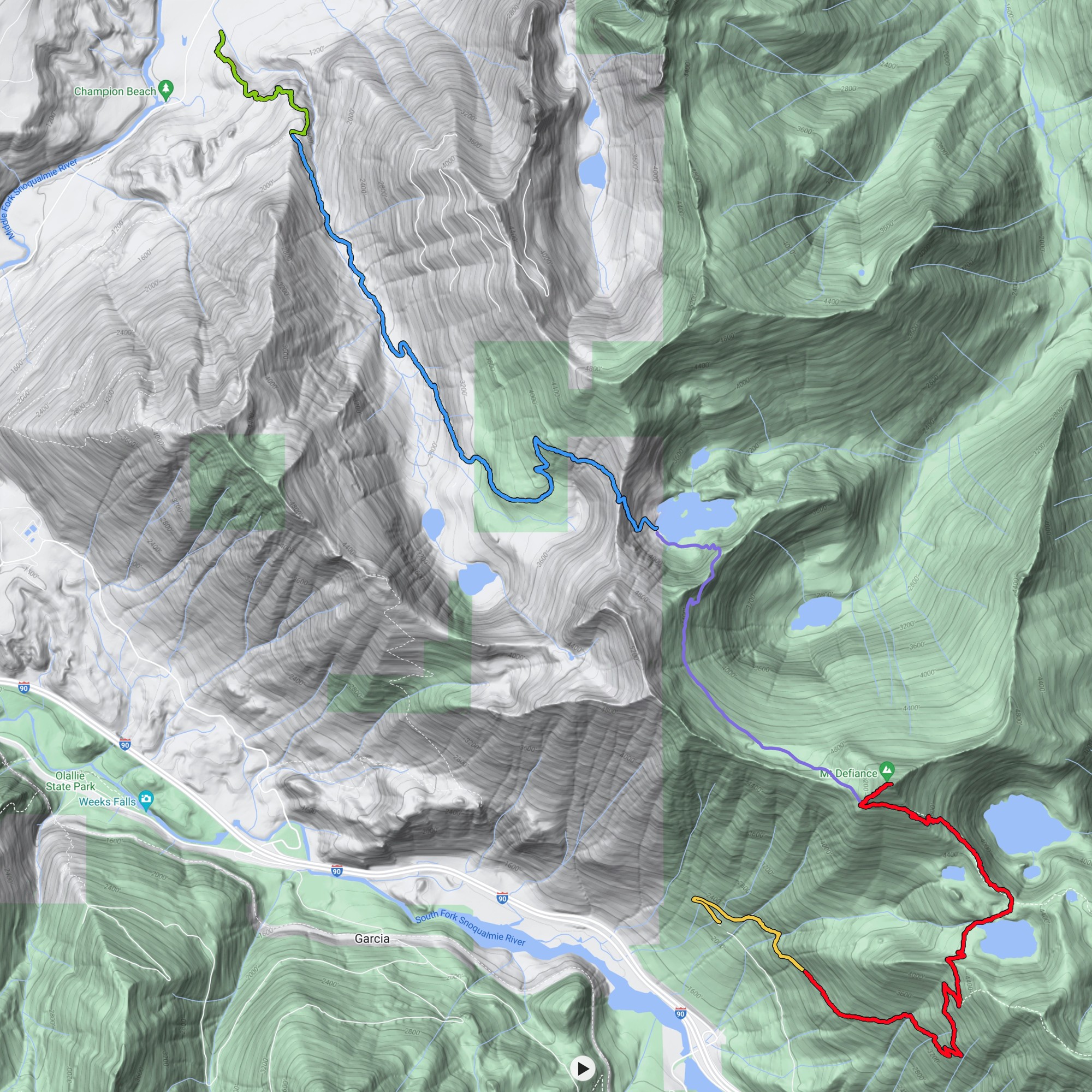
If you look at this map (directly below), which is from the Granite Lakes trailhead (going clockwise) and from the Ira Spring trailhead (going counter-clockwise), you'll see five distinct trail segments:
- Green: that's the first mile of the Granite Lakes trail, which I usually hike, as a warm-up, because it's so steep (900' of elevation gain in one mile).
- Blue: that's the Thompson Lake Trail, which I've run approximately 1 2, 3, 4, 5 times.
- Purple: that's the connector, which I have not yet run (I have some notes on it below.)
- Red: that's the Mount Defiance trail, which I've also run approximately 1, 2, 3, 4 times.
- Yellow: that's the first mile of the Mount Defiance / Ira Spring trail, which I usually walk, as a warm-up[1]. It's about 500' of elevation gain.
NOTE: This image is clickable, as it contains fairly detailed data.
You can download it here
(2000x2000 pixels, approx 1MB).
NOTE: This run would begin at Exit 34, about 6 miles into the SE Middle Fork Road (6 miles past the intersection at Valley Camp) at the Granite Creek Trailhead. It would end at Exit 45, three miles up the forest road (FR-9030), at the start of the Ira Spring Trailhead.
Here's the breakdown of each segment in terms of distance and elevation gain.
- Green segment: I usually hike this as a warm-up, as it's really steep. It's 1.0 mile of distance with 900' of elevation gain.
- Blue segment: The trail to Thompson Lake. It's a tough one. It's 4.0 miles of distance, with 2,390' of elevation gain.
- Purple segment:
The connector trail. Here's what I know, from WTA.org:
"2.6 miles of ridgeline traverse bring you to yet another backbone, where you may be able to spot Spider Lake and creek in the basin to the southeast. But you're heading to the northwest. Thompson Lake lies at the base of several steep switchbacks, just 0.8 miles away."So, about 3.4 miles of distance.
To get out of the Thompson Lake basin is approx 500', then, between the ridge and the Defiance Spur turnoff, it looks like you drop to approx 4,600', then run up to the spur turn-off at 5,150' .. so, 650' more feet of elevation gain, for a total of 1,150' of elevation gain. - Red segment + yellow segment: The Mt Defiance trail. Elevation gained on the way down is only 200', which is mostly getting out of the Mason Lake basin. The total distance is 4.9 miles.
In summary:
TOTAL DISTANCE: 13.3 miles (1.0m + 4.0m + 3.4m + 4.9m)
TOTAL ELEVATION: 4,640' (900' + 2,390' + 1,150' + 200')
NOTE: This would begin at Exit 45, three miles up the forest road (FR-9030), at the start of the Ira Spring Trailhead. It would end at Exit 34, about 6 miles down the SE Middle Fork Road (6 miles past the intersection at Valley Camp) at the Granite Creek Trailhead.
Here's the breakdown of each segment in terms of distance and elevation gain.
- Yellow segment: The first mile of the Ira Spring Trail. I usually hike this as a warm-up. It's 1.0 mile of distance and 500' of elevation gain.
- Red segment: The trail to Mount Defiance, minus the spur. The distance (without the spur trail) is 3.8 miles. The elevation gain is 2,670'. (The spur turn-off is at 5,510' of elevation, which I'm using for all calculations).
- Purple segment: The connector trail. Here's what I know, from WTA.org:
"2.6 miles of ridgeline traverse bring you to yet another backbone, where you may be able to spot Spider Lake and creek in the basin to the southeast. But you're heading to the northwest. Thompson Lake lies at the base of several steep switchbacks, just 0.8 miles away."So, about 3.4 miles of distance.
From Mount Defiance, you'll start at 5,150', drop down to approx 4,600', and then ascend to the ridge above Thompson Lake (approx 5,250'), for a gain of 650' between Defiance and Thompson Lake. - Blue segment + Green Segment: The Thompson Lake trail. The only elevation gain here is right at the beginning, to get out of the lake basin, and it's 500' The total distance: 4.9 miles.
In summary:
TOTAL DISTANCE: 13.1 miles (1.0m + 3.8m + 3.4m + 4.9m)
TOTAL ELEVATION: 4,320' (500' + 2,670' + 650' + 500')
So, both are just over 13 miles .. but clockwise looks like it's more elevation gain (4,640' vs 4,320'), and when you're trying to run up/out of the Thompson Lake lake basin, every foot of elevation gain is agony[2][3], so counter-clockwise it is.
This one would be very ambitious for me. I generally target about 10 miles and about 2,640' of elevation gain[4].
I've run a couple of comparable/close-ish runs, but nothing as long nor as steep:
- Lake Thompson + Granite Lake: 10.6 miles / 2,947'.
- Mt Defiance via Mason Lake : 9.0 miles / 3,150'.
- Mt Defiance via Mason Lake : 8.8 miles / 3,172'.
- Pratt Lake : 10.2 miles / 2,708'.
The only concern I think I have is water sources between Mount Defiance and Lake Thompson (in that: there are none). On a warm/sunny day, I'll drink 30oz of water between Mason Lake and the summit of Mount Defiance, which is all that I carry. So that would leave 3.4 miles with no water (which is way too far).
So, for now/TLDR: I'm not sure... I need to think about the water problem.