My Relatively Ambitious Plan for a Trail Run
I was recently looking at a map of the Mason, Pratt, Olallie, and Talapus Lake area and noticed that two trail runs that I've run separately are actually connected.
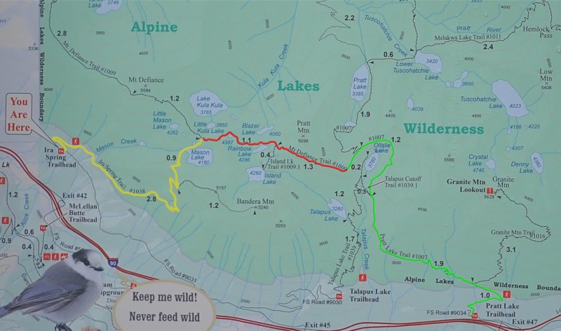
If you look at this map (directly below), which is from the Mason Lake trailhead, you'll see three distinct trail segments:
- Yellow: that's the Mason Lake trail, which I've run.
- Green: that's the Pratt Lake/Island Lake trail, which I've also run approximately 1, 2, 3, 4, 5 times, at various points having to resort to running part of the way to Granite Mountain instead when I was unable to cross a creek that was particularly dangerous due to some serious rainfall at that time[1], or having to re-reoute to Olallie due to snow ... or simply stopping up on the ridge towards Island Lake (also due to deep snow) and turning around.
- Red: that's the connector, which I have not yet run.
NOTE: These images are clickable, as they contain fairly detailed data.
There's no good reason I've never run the connector; I just didn't know it existed until a few weeks ago when I tried to run to Island Lake and was thwarted by really deep snow and had to turn back. (I got home and wondered: "Where the heck did I end up anyways?")
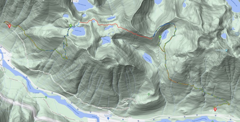
Anyways, here are two runs from this year, put on the same map. You'll notice it's the exact same area as that map above. The Mason Lake and Pratt Lake paths are actual Garmin data from those runs, while the red segment is the as-not-yet-run part of the trail:
Note: For those of you paying close attention, there's a small blue segment near Mason Lake. That's where I was just running for fun and to explore the area around the lake. I drew it in because the GPS data I ended up with is messy.
Now, are far as stats are concerned, here are some relevant ones:
- The run to Mason Lake is ~3 miles and ~1,800' of elevation gain. Note that I walked the 1st 0.33 miles on that ascent as a warm-up.
- The run to the Pratt Lake ridge is ~3 miles and ~1,800' of elevation gain. Note that I also walked the 1st 0.4 miles of that approach as a warm-up[2].
- The connector, according to the 1st map, is ~2.4 miles (1.1 + 1.3 on the 1st map).
- That would make the entire run approximately 10 miles, give or take.
- If you look at the contour lines for the red segment, they all seem to be around the 4200'-4400' range, so, I wouldn't expect significant elevation gain to be a problem.
- Total elevation gain, and this just an educated guess, would be ~2,500 feet.
- Also note, there are several water supplies along the way: Mason, Rainbow, Island Lakes, as well as some creeks on the Olallie/Pratt Lake side.
- I'd need a ride, as the trailheads are separated by 2 exits and ~3 miles of forest service road.
You might be thinking: do you know you can run that far?
Good question.
Check out this map of the same area:
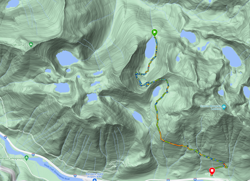
That's a run to Pratt Lake itself, which is 4.75 miles one way (~10 miles total, as I walked the 1st 0.4 miles up but ran it on the way down) with 2,000' of elevation gain.
You can see it's the same as runs shown above, for the first 3 miles, until I got to the lake basin ridge. At that point, I descended into the basin to run to the lake. I forget how far the distance is from the ridge to the lake but it's approximately 1.5 miles one way.
The way back adds an additional 740' of elevation gain (to get out of the lake basin and back to the ridge), for a total of ~2,700' of total gain for the run.
You can visualize wrapping the Pratt Lake Basin part of the run across the red segment (The Mt Defiance trail in the 1st image above) and it would connect to the Mason Lake trail and make a contiguous run.
So, I say: Yes![3]
Wish me luck.